Home
Rincon
Links
Maps
Island Images
Rincon Camera
Surf Contest '68
Surf Gallery
Hurricanes!
Georges
Relocate
(Personal)
Bikes
Boats (soon)
My Daughter

|
Hurricane Hugo The Log, the Photos EXCERPT FROM September 18, 1989 Hurricane Hugo Log! Tropical Storm Hugo reported at 12.7n, 42w. Although the storm is over 1500 miles
away, commented in a letter I was writing to Maud that I had a very strange and strong
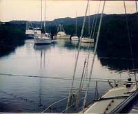
feeling about this one. September 14th: Hugo reached hurricane force. Plotted eye at 1,120 miles away from Culebra. September 15th 08:15 Underway with "Isla Bonita", a forty foot trawler I was looking after, for
the mangroves. Immediately ran dinghy back to pick up "Sea Fox". Got both boats,
side by side, in tight into mangrove islands in Bahia Honda. Did quick tie up and ran
dinghy across bay to town to pick up supplies. Wrote in the letter to Maud, my crew who
was visiting parents in Sweden, "Am getting this letter off now and going back to
boats to secure and prepare for Hurricane Hugo. If Hugo does as I strongly believe it
will, we will be 'ground zero'. Probably won't be able to get in touch by mail or phone
for some time after he passes. Don't worry if you don't hear for awhile. I'll be fine.
Like Buffet said, 'If the phone doesn't ring, it's me.'" I have never predicted a
hurricanes path before, in all my decades in hurricane waters, so I'm careful to get a
clear postage date stamp to prove that my prediction was made when it was still about 900
miles and two and a half days away. 11:00: Back to boats and securing for hurricane force winds.
OLE Cap'n Jim Playing mangrove monkey! 15:00: Just heard that Hugo had attained winds of 120 mph. Have been crawling through
mangrove swamp building a 'spider web' of lines around both boats into the larger mangrove
trees. Still have lots to do just tying up. 21:00: Finished tying up just at dark. Listening for hurricane updates while checking out
both boat's systems, (bilge pumps, engine, generator, etc.). Will probably be up most of
night listening for developments to get idea of what to prepare for tomorrow. Will catch
little naps when I can. September 16th 14:00: Stripped "Sea Fox" to bare poles. Nothing that can come off is left above
decks. At noon reports from Hurricane Tracking Center in Miami place highest winds at 130
mph and not expected to strengthen in next 24 hours. Starting to strip "Isla
Bonita" of awning, antennas, etc. 1800: Hugo was showing sustained winds of 150 mph. 19:30: Finished majority of preparation. Even switched wind speed indicator to inside of boat so I can keep track of winds and record. Am sore and tired. Will rest a bit and eat something. Have been living on milk and Oreos for last two days. No time for anything more. Heard on radio that Hugo started a northward curve but didn't catch all of report.
That's not a good development, but exactly what I expected. 20:30 Hugo located by Hurricane Hunter airplanes at 16°N, 60°W, moving WNW at 12 mph.
Max sustained winds down to 140 mph. Storm force winds extend out 150 miles to north and
east of eye. Simply must stop, cook something, and get some rest. 20:50 Winds here at 2-4 knots from east & N.E. Still listening for reports, scanning
several sources on AM and VHF radio. 23:00: Radio 100 in St. Thomas reported that as of 08:00, the 17th, the airport will be
closed until further notice. 23:30 Hugo predicted, on present path, to pass directly over St. Croix and then hit the
north east coast of Puerto Rico. Guess what is off the north east coast of Puerto Rico?
Culebra. Did I say ground zero? September 17th 01:30: Slept a bit and woke up somewhat refreshed. Conditions same here. 02:00: Last position plotted at 16.3 N, 61.1 W. It is calm out and a bright full moon shining from a clear sky. From conditions here, it is hard to believe anything is happening out there. However, looking at the plotting chart is like looking into the barrel of a very large gun. Brewing coffee. 02:15 Just heard Hugo hit Guadeloupe. First reports in are power out. No shit. 0300: Coordinates 16.4 N -61.8 W. Reported 150 knot winds on Guadeloupe. That island reported to have 3000 homeless. Fires broke out but are under control. 0315 Checked out trawler. Shut off refrig. All systems up. 1030: Too busy to write in log. At 0930 Civil Defense in Culebra broadcast on VHF FM that Hugo was predicted to make a direct hit and everyone must leave their boat by noon today. Bullshit. 1035: First little rain band passed. Reading 8 to 10 knots from E. More to do while sun is shining again. 1300: Running engine on trawler to charge batteries. All that's left is to remove engine and gas tank on dinghy and fill dinghy with water. At 1115 wind started gusting a bit. Now gusting to 25 knots. 1200: St. Thomas reported a highway blocked by fallen trees already. St. Croix reported gusts to 60 knots. 1405: Isle 95 in St. Thomas off the air. Feels great to sit down for awhile and relax. Felt like Rambo a few minutes ago; sharpening knives for cutting and clearing lines, adjusting life vest, jeans on with belt and knife sheath, boat shoes in the right place, foul weather gear ready with rubber bands for sleeves and cuffs. That's OK. Rambo I'm not, but I ready for the storm. Have done lots more on boat than most others nearby. Even lashed bitter ends of lines and really secured everything. 1420: Radio 1 in St. Thomas sent message out from the Hurricane Center in St. Thomas. "It's too late to worry about saving your property, so save your life. 1720: Person in Rosendal area of St. Thomas reported recording 60 knots sustained and gusts to 80. Most phones and all power is off in Antigua. 5000 reported homeless in Guadeloupe. Most power is off in St. Thomas and only one feeder is working in St. Croix. I'm as ready as can be, both personally and boat wise. There's nothing else I can think of doing. I would like to say all will be well because of my level of preparedness, but it's also up to the other boat captains preparedness on the boats around me. Hoping for the best. Soon the winds will be up to hurricane force, at least in gusts, and then the lines and leads will have their first test. I'm exhausted from three days of single handed preparation and hope to get some rest before the shit hits the fan. 1720: Rest doesn't seem to be in the schedule. Just finished re-building the fresh water pump on the engine of the cat ketch. Must have engine to keep batteries up and to help tensioning lines, so it had to be done. Would you believe engine would go down in the middle of a hurricane? I would. Murphy's law. Montserrat reported hospital totally destroyed. St Thomas already getting minor damage. I'm registering gusts to 40 now, but I'm in the lee of a little hill and in the middle of thick mangrove. All holding well. Waiting for 2100 storm update. 2030: Boats have already started breaking loose around Culebra harbor, but none near me yet. One is a 42' ketch heading right toward boats anchored near the village. 2050: Large trawler reports sweeping down on "Slow Motion", who just cut them loose to drift through the rest of anchorage. And the hurricane hasn't even hit yet! What a mess it will be tomorrow. Trawler involved is "Legend" 2055: "Legend" just swept into mangroves in Sea Bourne Harbor. The crew is ashore and in shelter. 2110: VHF channels are crackling on scan with problems. Just got a solid 45 knot gust. Wonder what 150 will be like. 2115: Made rounds of lines. All OK, but it's going to be a long night. 2130: Cooked something 4 hours ago, and just now sitting down to eat. Radio reports that Skyline Drive in St. Thomas is now blocked totally by downed trees. 2149: Governor Farrely of Virgin Islands activated Emergency Broadcast System and set curfew. 2200: CBS News reported that several buildings on St. Croix had collapsed, boats were cast up on the shore, etc. 2230: Checked and tightened all lines. The mangroves are the place to be. Boats in harbor are reporting winds to 80. Here not nearly as bad. So much for the "anchor clear and swing free" theory. September 18th 0030: Gusting more at my location. Another bunch of boats started dragging. 0040: Radio 1 reports the Towers Apartments top floor is collapsing and Warren Brown Apartments is evacuating as the roof is off. Air Force Recon plane reports eyewall is over St. Croix, placing it further north than original report. Also, a tropical depression that is about 700 miles east has been upgraded to tropical storm. Hope it's not going to be another one-two hit like David & Fredric! No one has heard from St. Croix for quite awhile now. 0100: More boats dragging. It's not even at its worst yet! It'll look like a yacht junkyard here tomorrow. 45' boat hit "Halcyon" and one other. "Halcyon" reports it right across the bow. I'm still trying to catch a cat nap. 0230: Wind and rain picked up more. Checked both boats and dinghy. It almost looks like a hurricane out there. Listening to AM and monitoring about 12 channels on VHF scanner. One boat reported that it was holding against the wind on anchor only by running engine. Quickly caught the anchor line in wheel (prop) and is now adrift without propulsion. Another incidence of the prevalent "anchor clear and swing free" theory. "Lady Barbara" is on the beach. 0402: "Slow Motion" is up against "Legend" now and breaking up. They report the whole port side is smashed. Doug from "Slow Motion" is aboard "Legend" now with his mate. 0415: Sheets of rain slamming against cabin. Getting toward max now. Time for a walk on deck. 0430: All commercial communications in St. Thomas are down. 30% of buildings are damaged. National Guard Commander reports it will be impossible to leave his post to evaluate damage and give aid for at least five hours. 0500: Latest position shows Hugo eye 24 miles from Culebra. Talk about "living in the eye of the storm". Blowing like stink out there, but both boats still holding well. 0510: "Orion" adrift and dragging through anchorage. 0515: "Amitz" is maydaying. Reports they were hit by floating mangrove island with a house on it. They are breaking up. The boat is near Cayo Perda. 0530: "Amity" and three other boats are on the beach. 0542: Just got laid over to 35 degrees by strong gust. Expecting worse soon. 0547: Solid gust pitching boat against port lines. Starting to see first light, but it looks gray and ominous. 0550: Boats started breaking loose in my channel. I'm on deck with fenders. 0602: It's fierce out there. Cat ketch knocked down until rail was in water while I was on deck. I couldn't even see deck cleats for the mangrove leaves on deck. Nothing to do but hold on. (The cat ketch was a very stiff boat with a high freeboard. In 40 knots wind and full sail she couldn't be knocked down that much, and this was under bare poles! I've lived and sailed in hurricane waters all my life. I've even been through 2 hurricanes in mid ocean. Still, while experiencing Hugo's forces I said to myself "I've never seen a hurricane before!") 0610: Incredible! It's like being at sea and I'm in a 35' wide channel! Rain is blowing horizontally. Lines are creaking but everything is holding so far.
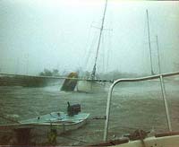
The inflatable dinghy beside the catch in the foreground was about 21' and had a high power outboard on it. Moments after the photo was taken, the dinghy sailed up on the painter like a kids kite, broke loose, and serenely sailed over the nearby hill and disappeared. Whew!
0635: Boats constantly calling Mayday. Not to request help, because help was impossible, but simply reporting their plight and then going on with the business of surviving. 0640: "Antares" going down. "Esperance" broke loose from head of the mangrove channel I'm in. Too much happening on other boats to chronicle all. One boat reports abandoning ship. "Abandoning ship. Good luck to all! Hope to see you ashore. Out". The harbor and island must be a disaster area. Maydays abound. Even masts are blowing down on boats within 50 yards of my position in the mangroves. 0650: Wind shifted to South East. Good. Means different lines will be worked and others get a rest. Hugo beginning to pass. 0702: Just lost wind indicator and VHF antenna on mast top. That's OK. Didn't want to know how much it was blowing anyway. 0730: Vieques Island reports eye overhead. Report winds of 140 steady. NO! Eye overhead here now. Clear skies showing. Multiple eyes? Very possible. 0800: Going in water. 0840: The starboard bowline on the trawler broke, carrying her port bow into the cat ketch. Main danger was the trawler breaking loose and being carried down on seven or eight boats downwind. Rigged in snorkel gear and hit the water swimming from cat ketch to trawler. Rigged two lines, tied around my waist, and porpoised under and through submerged mangrove roots to find point to secure them. Couldn't take up any slack on them when I got back to the trawler to pull it off the cat ketch, even with the power winch. Started trawler engine, went to full ahead, and added winch power to pull it back into place. Wind is incredible. I even had to keep the dive mask on to work on deck. The wind is shaking and buffeting the boat now even though the wind is on the bow! Boat pitching about as if at sea. The wind is blowing solid sheets off the surface of the water and blowing it and down the channel. Only occasionally catching glimpses of boats downwind. Just hope that "Harmony" and "Red Shoes" ahead of me hold. Many boats filled the dinghy with water. Current wind conditions have blown the water out of many, they broke loose, and sailed away out of sight. We're not talking about sailing along the surface of the water. They are flying away at a height of 50 to 150 feet in the air! My dinghy is doing OK. 0845: Thought I heard a small tornado pass but there is so much wind noise I don't know for sure. 0900: Lesson: Never say something is OK while in a hurricane! Moments after I dotted the
period on the 0845 entry, the water blew out of my dinghy. It flew up in the air, flipped
over and landed in the cockpit upside down. Quick, I dashed up, grabbed the bitter end of
the painter and secured it where it was. Talk about serendipity. (After the storm I took
considerable kidding about my unique method of bringing a dinghy aboard and securing it). A boat in the main harbor reported that there was a moment in the harbor that the wind and spray let up and they counted at least 40 boats cast high and dry on the beach. That was just in one small area! Another said the area he was looking at resembled a graveyard for yachts. I'm shifting to call and distress channel and closing one eye. It's still not nearly over and I'm running on empty. 1045: Calming some out there. Well, down to 60 to 80 is calm compared to 140.
Checked and re-adjusted all lines. Realized the leather gloves I was using during
storm are in shreds, but my hands are OK.
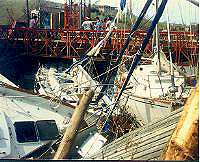
September 18th 14:14: It's down to a dull roar now. Going into town in dinghy. Heard that 80% of houses on island were destroyed or severely damaged. 18:27: God, the devastation! Almost every shore of Ensenada Honda was littered with yachts, piled one on the other. huge sailing vessel "September Morn" and numerous other yachts are piled under and into the bridge at Dewey. (Photo above.) Marta's upstairs dining room and Terrace is destroyed. Lots of damage in Dewey. Church gutted and roof destroyed. Within 50 yards of my boats in the mangroves there are four boats high and dry and three dismasted under bare poles. Kick ass storm. No communications at all into or out of the Virgin Islands except for Ham operators. Tomorrow will chronicle some of the yacht and island damages. Will finish this log with that, with the exception of updates on people missing from yachts. September 19th: Yacht "Phoenix" reports Lloyds of London is sending a crane barge from Miami because of massive damage to yachts in area. "Fantasia" reports 90% of houses in St. Croix destroyed. St. Thomas devastated also. AM station in St. Thomas is first USVI station back on the air since storm. Reports of WAPA (St. Thomas electric company) restoring power to Radio 13, and Vitelco (phone company in St. Thomas). They report a massive amount of downed lines and say it will be weeks before power is restored to all. (St. Thomas is only about 13 miles long!) St. Croix is said to have about 90% of power station destroyed! Governor of US Virgin Islands has set curfew at 10 PM. Later he declares state of emergency - looting rampant in VI - devastation incredible, situation critical. US Customs building in St. Thomas reported gone! Yacht harbor of Christianstead and Galllows Bay in St. Croix devastated. Ship harbor in Fredricstead, St. Croix in bad shape. Hospital in St. Thomas report receiving burn patients, among other injures. National Guard helos destroyed in St. T & St. X, along with planes and hangers. Control tower for St. T. down. Reports of 25 dead in Puerto Rico and 30,000 homeless at this point. September 20th. 0627: Radio in St. Thomas reported "Louie" Rama (an old West Indian friend of a long time) died in storm. Prime minister of the Island of Nevis reports 90% destruction of island. St. T. denuded, 50,000 homeless in St. Thomas, 80% of agriculture lost. Report from CBS claims Culebra hit the worst, including total destruction of the hospital. St. Thomas reports not one boat in Charlette Amalie harbor survived. Red Hook harbor devastated. Dinghy ride from boats to town showed the following: Only 3 boats afloat in Fulison Harbor, huge catamaran flipped and floating upside down, ferry boats on shore. I counted only 5 boats afloat on way to town out of the mangrove area. Devastation to power and sail yachts is incredible. Later: It was estimated that 98% of charter boat fleet sheltering in Culebra was damaged or sunk. We're not talking about only small cruising yachts personally owned alone here. There were many large, world class yachts destroyed, never to be under sail again. What a loss! Reports from the Alcaldia (Mayors office) in Culebra were that their anemometer carried away at 247 miles per hour. Not sure of their accuracy, but am sure about the one at Roosevelt Roads Naval Air Station nearby on the main Island of Puerto Rico. A weather person on duty during the storm told me their anemometer carried away at 256 mph. She showed me a copy of the tape readout to prove it. 256 mph, whew! Hugo was one serious storm! |